About two weeks after Utah 115, just as I started jogging slowly to get back in motion, an idea came to me.
The weather was cooler than normal for this time of the year and raining a lot more than normal as well. I have had my eyes on doing the entire 57 miles of Rampart Range Road (RRR) for the past year. As far as I can tell from Strava and FKT sites, only four people had done it, and all had done it in the supported style.
The issue with unsupported style on the RRR is a lack of water source. RRR mainly follows the spine of Rampart Range and most streams originate somewhat downhill from the road. Topo map does show some small creeks that start within a couple hundred yards of the road but those are all seasonal. The only truly reliable source is at Rainbow Gulch where about half a mile down the Rainbow Gulch trail is a significant perennial stream that drains into Rampart Reservoir. This water source is 39 miles from the start of the northern trailhead.
RRR is a perfect supported style route since the dirt road is wide and graded so any vehicles any easily navigate it and follow along a runner to provide water, food, supplies and pacers. The ideal time to run the RRR in a supported style is in late October or November, before snow coverage and RRR closed for vehicle traffic for the winter. For unsupported style, perhaps early April would be good depending on snow condition, since RRR opens for vehicle traffic sometimes in April. No one that I'm aware of has done unsupported style and generally there are no condition reports for that time of the year for the middle section of RRR to provide any historical experiences.
Two weeks after Utah 115, I started to feel normal except for a bit of lingering hip soreness, a left heel blister had popped cleanly and healing, and a right heel blister that did not pop so was still covered under the callus. I decided if the blisters and hips continue to improve during the week, I would give RRR a shot on Saturday while the weather was cool and road was wet. A damp road significantly reduces dust from car traffic.
It rained hard every day during the week and by Friday, I was feeling like I could give it a go. Saturday's forecast was pretty good. Majority of RRR was at 9,000 to 9,500 ft. Forecast for the 9,000 ft elevation was a low of 41 and high of 65, sunny and slight chance of rain in the afternoon.
I wanted a 5 AM start so to not have to use lights and also to maximize the daylight running time. I went to bed at 9:30 PM on Friday night, only to wake up at 11:40 PM and could not go back to sleep until past 1:30 AM. My alarm went off at 2:15 AM.
I had tried an Osprey waist pack carrying two 24 oz bottles during the week, but they bounced too much without cinching the belt tighter than comfortable. So I had to load everything into the Salomon Adv Skin 12 pack.
My pack load:
Rear main compartment:
- Two HydroPak UltraFlask 500mL bottles with caps, each mixed with two scoops of Tailwind.
- 2.5L bladder filled with water.
- 4 bags of Tailwind powder, each bag has two scoops (100 calories per scoop)
- 4 Lara Bars (100 calories each)
- 3 Cliff Bars (250 calories each)
- 3 Roast Beef Sandwiches ( 370 calories each: 2 slice of bread (70C each), 2 slice of cheese (80c each), 3 slices of meat (70C/3 slices))
- Full emergency kit including bivy, emergency headlamp, knife, water purification pills, duct tape, Band-aids, parachute cord and blister kit
- Fenix Headlamp
- Garmin InReach
- Toilet Paper
- Wet-wipes
- Water filter with 1 liter soft flask, empty
- Waterproof pants
- Rain jacket
- Battery and cable
- Pole quiver
Front pockets:
- Two Salomon 500 mL soft flasks, each mixed with two scoops of Tailwind mix.
- Left side has gloves, buff, arm sleeves, AfterShokz and phone.
- Right side has medicine kit (Tylenol, Ibuprofen and Salt-sticks) 2 Lara bars, 1 Cliff bars.
Total water carried including Tailwind mix carried is 4.5 liters that weigh 10 lbs. Total pack weight including hike poles is around 20 lbs. Probably could shaved the pack weight down to around 15 lbs by only packing food. With the amount of vehicle traffic on the RRR, most of the emergency stuff are really overkill. But this run is also a good dress rehearsal for the White Rim so I decided to go with the a setup close to the White Rim setup. The White Rim self supported setup would only add Kogalla waist light, one 18650 battery, and more food. The White Rim unsupported setup would added another 8 liters of water which is 17 lbs. and also would have required a bigger pack.
Jade dropped me off at the northern trailhead off Hwy 67 at 5 AM. To our amazement, there was a telephone booth there. We tried it and it had a dial tone. But we didn't have the two quarters required to make a call. That would have been fun to do.
 |
| Old School! |
 |
| At the start |
I started up the RRR at 5:12 AM. After a hundred yards or so, the pavement ended. The first ten miles of the road gently gains 1,400 ft from 7,600 ft to 9,000 ft. I alternated between walking the hills and slow running the flats in this section.
Since the water had to last for 39 miles, I settled on using the Tailwind bottle as the water pacing tool. One 500 mL bottle of Tailwind every 9 miles. Since I tend to sip the similar amount of water after each sip of Tailwind, I figured this will get me to 36 miles with around half of liter of water left. That should be enough for the remaining 3 miles to Rainbow Gulch.
Food strategy is 200 calories per hour. I had thought the roast beef sandwich had around 250 calories. After the run I checked the nutritional content of the labels and found each sandwich had 370 calories! I decided to eat the sandwich as treats at mile 15, 30 and 45.
The pack was definitely heavy with weight mostly rear biased. I could feel the rear weight of the pack pulling the front of the pack up a bit.
There were many campsites in the first 6 miles and a surprising amount of vehicle traffic that early in the morning. They were mostly driving very slow and respected my space. I also noticed many drivers looked like teenagers. Maybe this is a good spot to teach a teenager how to drive?
This area of Pikes National Forest has many cool rocks, maybe left over Pikes Peak granite?
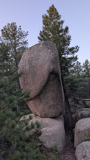 |
| One of many cool looking boulders along the RRR |
 |
| Sunrise hitting the forest |
 |
| I'm very very long |
What surprised me was the mile markers. Not sure if this was new since I certainly have not seen them on the southern portion of the RRR.
 |
| Only 50 miles to go |
Shortly after the road split at
Devil's Head Lookout Tower at mile 9, I finished the first bottle of Tailwind and stopped to swap with one of the full Tailwind bottles from the rear pocket of the pack. This took a bit of time but really helped with shifting the weight forward and making the pack more comfortable. Hindsight, I should have used the
Zpacks Multi-Pack to bring more weight forward for balance and comfort.
At mile 14, I couldn't resist the temptation anymore and ate the first sandwich a mile early :)
 |
| A bit of downhill! |
 |
| Found a good view point, there weren't many in the first 20 miles |
At some point, Pikes Peak makes her first of the many appearances. This run is akin to a love affair with Pikes Peak. Really couldn't get tired of look at her from different angles and lights.
 |
| First glimpse of Pikes Peak |
 |
| Perfectly framed by the road |
Shortly after mile 20, I heard moving water then a stream that's running off to the left of the road. This definitely wasn't expected. On the topo map, dotted streams are intermittent streams or ephemeral streams. This stream was marked with dotted lines on the topo map and the only one that crossed the RRR. The previous week of rain must have saturated the soil quite a bit to make this stream flows so much.

I had to make a decision. By now I had consumed over 2 liters of liquid. More importantly, the rear of the pack is around 5 lbs lighter than when I started since I had shifted both full bottles from the rear to the front and had drank just over one liter of water from the bladder. The pack at this point actually felt fairly comfortable and the comfort level would continue to improve until Rainbow Gulch at mile 39. If I refill the water from the stream here, the pack would instantly be uncomfortably heavy again. Essentially I would increase the total carrying to an additional 5 lbs for 19 miles. But this would also eliminate the one mile round trip detour at Rainbow Gulch.
I decided to refill here, deal with the weight and skip the Rainbow Gulch detour. The water was a bit muddier than I liked and soon I realized a feeder crossed the road into the stream and added mud from the road surface. Fortunately it didn't clog up the filter and the resulting water tasted fine.
The vehicle traffic pretty much died down after mile 12. I only saw a few motorcycle riders, two gravel bike riders and a handful of cars during a 15 miles stretch. Things changed rapidly as I approached the junction with Mt. Herman Road. Not only vehicle traffic increased, they were also fast. I even saw a couple pickups sliding around bends. The road is no longer damp after baking in the sun all day and this caused a good bit of dust with each vehicle flying by. This area also allowed shooting and for about 3 miles from mile 33 to mile 36, I felt like I was in a shooting gallery. I could even identify the magazine size by the shooting intervals. It also felt hot even though the temperature was only in the mid 60's. The higher elevation and cloudless sky meant more solar exposure. The vehicle traffic continue to increase until mile 40 at Rampart Reservoir entrance.
 |
| I was very glad to run past this sign |
The trees opened up quite a bit after mile 30 and there were many views of Pikes Peak.
 |
| Shortly after Farish junction |
 |
| Close to Rainbow Gulch was a section of wide open views |
After the entrance of Rampart Reservoir at mile 40, traffic disappeared. It was finally peaceful and the increasing cloud cover had decreased the apparent temperature to a much more comfortable level.
 |
| Peacefulness amount the young aspens |
 |
| Getting cooler |
I ate the last sandwich at mile 43, anticipating the upcoming downhill where I would not want to slow down to eat. I had saved the last two bottles of Tailwind for the 11.2 miles of downhill.
Finally just before mile 46, I went around a left bend and arrived at a summit point. 11.2 miles and 3,000 ft of descend lies between me and the finish at Garden of the Gods.
 |
| First view of the Colorado Springs, from the final "summit" |
 |
| RRR courses its way down the spine |
I put the poles away in the quiver for the last time and focused on my leg turn overs. To my dismay, my body refused to go faster than a 10 min pace. Mostly I was stuck between 10:30 to 11 min pace.
 |
| Williams Canyon basking in the setting sun |
I texted Jade just after the Queen's Canyon overlook with about 3.5 miles to go and joked to her that my ETA is 7:43 PM and 30 seconds. Somehow she thought I was serious!
Somehow I beat my WAG ETA by 3 minutes and finished at 7:40 PM. There were still quite a bit of tourists at Balance Rock, and Jade wasn't there yet. I called her and she said she was 8 minutes away with freshly made Vietnamese food in the car for me!
Going through my pack that night, I had two Lara bars and one Cliff bar left. The main bladder had maybe 5 oz of water, and one soft flask of Tailwind was half empty. So the tally of the total run consumption:
Food:
- 4 Lara bars (400 calories)
- 3 Cliff bars (750 calories)
- 3 roast beef sandwiches (1,110 calories)
- 5.5 bottles of Tailwind (1,110 calories)
Total: 3350 calories, averaging 231 calories per hour. This beat my goal of 200 per hour mainly due to under-estimate the sandwich calories! This also explained that I did not experience any bouts of low energies.
I started with 4.5 liters of water (counting water in the Tailwind mix). At the mile 20 creek, I filtered 2.5 liters of water into my bottles and bladder, and drank another 300 mL of water directly from the filter. At the end I had perhaps 400 mL of water left. So the total water consumption was 6.9 liters, averaging 475 mL per hour in this condition: 41' to 65', sunny, light breeze and cloud cover in the afternoon. Extrapolating this to 30 hours will require just over 14 liters of water. So an unsupported White Rim with 12 liters will need to occur in cooler weather, while a self supported run could be done in similar condition as RRR on Saturday but the water stash will have to be more than 1 gallon each.


No comments:
Post a Comment